Hiking trips
 Let Pado record your excursions and hiking or cycling tours so that you can track which routes you took, how fast you went, where you took a break, etc.
Display and evaluation of the tracks on a map with graphical representation of speed and altitude in charts.
Wandern, Ausflüge
Lassen Sie Pado ihre Ausflüge und Wander- oder Radtouren aufzeichnen, damit Sie nachher nachvollziehen können, welche Wege Sie genommen haben, wo Sie wie schnell vorangekommen sind, wo sie Pause gemacht haben, usw.
Darstellung und Auswertung der Tracks auf einer Karte mit graphischer Darstellung von Geschwindigkeit und Höhenprofil sowie Balkendiagrammen.
GPX/KML Export
 Export the tracks as a GPX or KML file for further processing in other
apps or on your Mac/PC, or to share them with other people.
Export the tracks as a GPX or KML file for further processing in other
apps or on your Mac/PC, or to share them with other people.
The GPX format is a standard format that is supported by most navigation apps and devices.
GPX/KML Export
Exportieren Sie die Tracks als GPX oder KML-Datei, um sie in anderen
Apps oder auf dem Mac/PC weiter zu verarbeiten, oder um sie mit
anderen Leuten zu teilen.
Das GPX-Format ist ein Standardformat, welches von den meisten Navigations-Apps und Geräten unterstützt wird.
GPX/KML Import
 Have downloaded GPX files from other apps or from the web,
you can also import and open them in Pado.
Have downloaded GPX files from other apps or from the web,
you can also import and open them in Pado.
Imported GPX and KML files are saved in the same way as normal tracks and can be analyzed in the same way.
GPX/KML Import
Haben GPX-Dateien aus anderen Apps oder aus dem Web heruntergeladen,
können Sie diese auch in Pado importieren und öffnen.
Importierte GPX- und KML-Datei werden wie die normalen Tracks gespeichert und können wie diese ausgewertet werden.
Traveling, vacation
 When traveling, the app can automatically record your movements so that you
can later see when you visited which sights.
To do this, the app can automatically start recording a track
as soon as you leave the hotel and stop when entering it again. This means you can no longer forget to manually start the recording. Instead you can just enjoy your vacation.
When traveling, the app can automatically record your movements so that you
can later see when you visited which sights.
To do this, the app can automatically start recording a track
as soon as you leave the hotel and stop when entering it again. This means you can no longer forget to manually start the recording. Instead you can just enjoy your vacation.
Reisen
Auf Reisen kann die App automatisch ihre Bewegung aufzeichnen, so dass Sie
später nachvollziehen können, wann Sie z.B. welche Sehenswürdigkeiten
besucht haben. Die App kann hierfür die Aufzeichnung eines Tracks
automatisch starten, sobald sie das Hotel verlassen und wieder beenden,
sobald sie dieses wieder betreten. Damit brauchen Sie sich um die
Aufzeichnung selbst gar nicht mehr explizit kümmern, sondern können den
Urlaub geniessen.
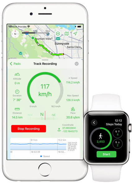
Sports
 Let the app record your sports activity.
The app can show graphically how your performance has
developed over time. The app can also perform the recording
fully automatically so that you no longer have to worry about it.
Let the app record your sports activity.
The app can show graphically how your performance has
developed over time. The app can also perform the recording
fully automatically so that you no longer have to worry about it.
The app can tell you by voice output about your progress, tell you about the current speed, distance, pace and more.
Sport
Lassen Sie die App ihre Sport-Aktivität aufzeichnen.
Die App kann Ihnen kann grafisch aufzeigen, wie sich ihre Leistung
im Laufe der Zeit entwickelt hat. Die App kann die Aufzeichnung auch
vollautomatisch durchführen, so dass Sie sich nicht mehr darum kümmern müssen.
Die App kann Sie per Sprachausgabe über den Fortschritt informieren, also z.B. aktuelle Geschwindigkeit, Tempo, Strecke und einiges mehr ansagen.
Time tracking
 The app can automatically log when and how long you spend at certain locations. Use this function if, for example, you need to know when and for how long you are working with customers.
All you have to do is define the locations to be monitored and the app does the rest automatically.
You can also export all data as a text or CSV file and visualize it in charts.
Zeiterfassung
Die App kann automatisch aufzeichnen, wann und wie lange Sie sich an bestimmten Orten aufhalten. Nutzen Sie diese Funktion, wenn Sie z.B. wissen müssen, wann und wie lange Sie bei Kunden arbeiten.
Sie müssen nur die zu überwachenden Orte definieren, die App macht den Rest automatisch.
Sie können alle Daten auch als Text- oder CSV-Datei exportieren und über Balkendiagramme visualisieren.
Devices
 The app runs on iPhone, iPad and Apple Watch. It uses GPS for the best
results, if available, but also works without GPS hardware
(some iPad models).
The app runs on iPhone, iPad and Apple Watch. It uses GPS for the best
results, if available, but also works without GPS hardware
(some iPad models).
Geräte
Die App läuft auf iPhone, iPad und Apple Watch. Es nutzt GPS für beste
Ergebnisse, sofern vorhanden, funktioniert aber auch ohne GPS Hardware
(einige iPad-Modelle).
iCloud
 Use iCloud Sync to automatically synchronize recorded tracks between multiple devices automatically.
This is helpful if you want to record tracks on an iPhone and then analyze them much more conveniently at home on an iPad with the larger screen.
iCloud
Nutzen Sie den iCloud-Sync, um aufgezeichnete Tracks zwischen mehreren
Geräten automatisch abzugleichen.
Dies ist hilfreich, wenn Sie z.B. über ein iPhone Tracks aufzeichnen, und diese dann zu Hause auf einem iPad mit dem größeren Bildschirm deutlich bequemer auswerten wollen.
The App Pado is all about
geo tracking.
Record and analyze the routes/tracks of your trips, hikes, excursions, bike tours, sports activities, etc. and display them on a map.
Use the pedometer to record and evaluate workouts.
Time tracking is also possible, i.e. logging when you are at certain locations and for how long.
All features can be used manually, but also fully automatically in the background via location-based actions, which makes Pado special and is not usually found in other apps.
The location-based actions allow the app to automatically trigger user-defined actions in the background (i.e. the app does not need to be active) as soon as you enter or leave certain locations. This includes recording routes/tracks, counting steps, displaying messages, playing music, and via "WebHook", actions can even be triggered outside the device (via a dedicated server) and the app can be integrated into your own home automation system, for example.
The app offers extensive configuration options for all features, as well as evaluations via charts and statistics; all data can be exported for further processing in other apps.
Pado also supports Bluetooth beacons, NFC tags (including AirTags) as triggers for actions.
Pado läuft auf iPhone, iPad und der Apple Watch
Bei der App Pado dreht
sich alles um das Geo-Tracking.
Zeichnen Sie die Routen/Tracks Ihrer Reisen, Wanderungen, Ausflüge, Radtouren, Aktivitäten im Sport usw. auf und werten sie diese aus und stellen diese auf einer Karte dar.
Nutzen Sie den Schrittzähler um Workouts aufzuzeichnen und auszuwerten.
Es ist ebenfalls eine Zeiterfassung möglich, also eine Protokollierung, wann Sie sich wie lange an bestimmten Orten aufhalten.
Alle Features lassen sich nicht nur manuell nutzen, sondern insbesondere auch über ortsbasierte Aktionen vollautomatisch im Hintergrund, was Pado besonders macht und man so in anderen Apps i.d.R. nicht findet.
Die ortsbasierten Aktionen erlauben es, dass die App automatisch im Hintergrund (die App muss also nicht aktiv sein) vom Nutzer definierte Aktionen auslöst, sobald man bestimmte Orte betritt oder verlässt. Dazu gehört das Aufzeichnen von Routen/Tracks, das zählen von Schritten, Anzeigen von Nachrichten, Abspielen von Musik, und über "WebHook" lassen sich sogar Aktionen außerhalb des Geräts auslösen (über einen eigenen Server) und die App z.B. in die eigene Heim-Automation integrieren.
Die App bietet für alle Features umfangreiche Konfigurationsmöglichkeiten, sowie Auswertungen über Diagramme und Statistiken; alle Daten lassen sich exportieren, um sie z.B. in anderen Apps weiter zu verarbeiten.
Pado unterstützt auch Bluetooth-Beacons, NFC-Tags (u.A. auch AirTags) als Auslöser für Aktionen.
Pado läuft auf iPhone, iPad und der Apple Watch